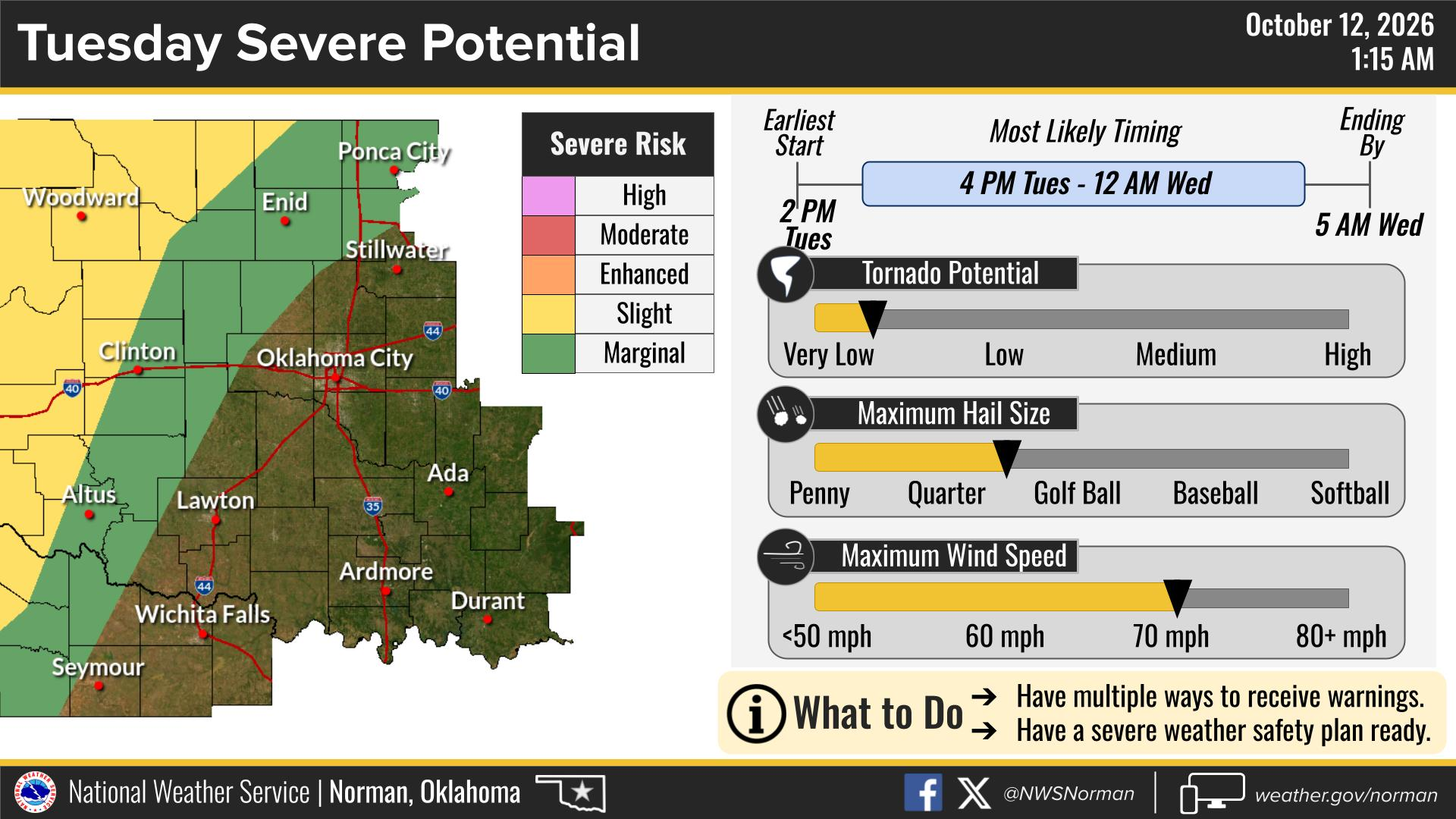
Strong to severe thunderstorms could bring damaging winds, large hail and a tornado threat to western and northwestern Oklahoma on Tuesday, Oct. 13, according to the National Weather Service. Oklahoma City’s rain chances increase Tuesday night, with more widespread storms and a flooding threat developing across the region Wednesday into Thursday.
The National Weather Service office in Norman said strong to severe storms are possible Tuesday across portions of northwestern and western Oklahoma. The strongest storms may produce large hail, damaging wind gusts and a few tornadoes, the office said.
On the SPC’s Monday midday map, Oklahoma City is in Marginal Risk, Level 1 of 5, while portions of western and northwestern Oklahoma are in Slight Risk, Level 2. The Slight Risk area runs through northwestern and western Oklahoma, but risk boundaries can shift as the event approaches, and storms firing along the dryline could track east.
Cold front timing
KOKH FOX 25 meteorologist Jack Gerfen said in an Oct. 9 forecast that a cold front approaching Tuesday evening would bring the area's first chance of storms after days of heat in the 90s.
"It'll be Tuesday evening when our cold front is beginning to approach the area, giving us our first chance of rain and storms," Gerfen said. He added that afternoon heat could fuel severe development.
Fellow KOKH meteorologist Connor Baldwin reported Saturday, Oct. 10 that strong to severe storms could fire along a dryline stretching from the panhandles into western Oklahoma on Tuesday evening. Baldwin said showers and storms would become more widespread across Oklahoma on Wednesday before a cold front pushes through Thursday, dropping highs into the 60s by Friday and Saturday.
National outlook
The NOAA Storm Prediction Center issued its Day 2 Convective Outlook on Monday, Oct. 12, placing a Slight Risk (Level 2 of 5) of severe thunderstorms over portions of the central and southern Plains for Tuesday afternoon into the night.
The SPC expects storm development by mid-afternoon from the Texas and Oklahoma Panhandles into central Kansas, with additional storms firing farther northeast by late afternoon into evening. Wind profiles favoring supercells mean large hail is the primary hazard. Tornado potential depends on supercell storm modes persisting into the evening, when the low-level jet strengthens near-ground wind shear, according to the outlook.
Threat extends into Wednesday
The danger does not end Tuesday night. NWS Norman said thunderstorms will likely continue into Wednesday morning, with the best chance for additional severe storms Wednesday afternoon and evening. All hazards remain possible. The office also warned that numerous rounds of showers and thunderstorms through Wednesday and Thursday could lead to flooding across the area.
The latest forecasts and any watches or warnings are available at weather.gov/oun.